
Creating a composition of geospatial policy layers to define where Policy boundaries and points lie, creates a Policy Map. The result of agreed and protected areas, as defined in the Local Plan. Every Council is obliged by law to produce detailed, digital maps, available to the public, online.
A particular constraint being that no Policy should be displayed on more than one map. Each Policy area, typically defined by the Settlement Policy Boundary and any adjoining Policies, is therefore presented in a single detailed map called an Inset Map. The example below shows a section of the Sharnbrook Inset Map.

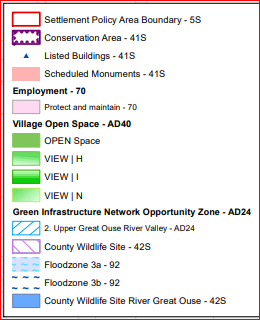
The Legend shows shows the relevant Policy Number which can be reviewed in the Bedford Borough Council Local Plan 2030.
All the Policies Maps for Bedford Borough are available to view or download here.